To the Top of the World
- elijahhicks0
- Nov 5, 2023
- 9 min read


After our time spent in the hilly jungle region of central western Costa Rica, we made our way south towards the highest peak in Central America, Cerro Chirripó. My hope was to see the impacts of tourism on another mountain village, with a different flavor. Whereas in Monteverde, most tourists are drawn by biology, in San Gerardo de Rivas, the town closest to the mountain, most tourists come for the adventure—to summit the 12,533 ft peak.

The town of San Isidro de General is smaller than you would imagine, for hosting the tourists to such a large mountain: one store, a school, a local church and a handful of restaurants. The difference from Monteverde, where we had spent the last few months, was apparent from the moment we drove into town. This is peculiar, because the mountains surrounding the Chirripó area have all the same ecological attractions as Monteverde, cloud forests, rolling hills, cool weather, countless species of birds and other wildlife, plus a mountain to climb.
We set our alarm for 3 am. The goal was to make it as far up the mountain as possible before the noon rains set in. Rolling out of bed at such an early time was difficult, but made easier by the local coffee and yogurt for breakfast. We had packed lots of tasty snacks for the adventure, including homemade no-bake cookies with cocoa nibs (mmm).
To get to the trailhead, we had to walk down our steep driveway to the mainroad, then up the steep main road for about three quarters of a mile. One of the especially noteworthy characteristics about San Gerardo, especially in comparison to Monteverde, is its steepness. Every road is extremely steep, and is not for the fainthearted to drive, or walk, for that matter.
To do the hike, we had to first reserve a two day permit, and a place to stay at the lodge. With the rainy weather, summiting the mountain in a single day was unrealistic. Plus who would want to miss the chance to stay at a mountain lodge?
The San Gerardo trailhead started at 5,376 feet above sea level. The lodge, where we would spend the night, is located 14.3 kilometers of trail away at 11,555 feet above sea level.

As we started the climb, the trail was largely a mix of red clay with rocks scattered here and there. Around us was cattle pasture and coffee plantation, something that baffles me with the steepness of the hills. How do they harvest and transport the coffee from these slopes? And those cows must be muscley beasts.
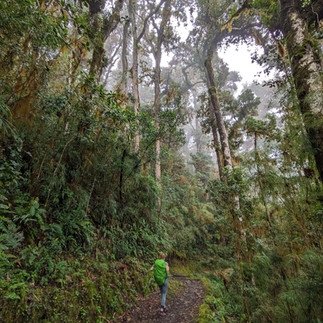
About 3 kilometers into the journey, it started to get light. The sun rose as we continued to climb, revealing San Isidro, and the ocean in the distance to our west. The cow pasture continued up with us until we were about 4 kilometers into our journey, at which point the jungle became more mature. Like Monteverde, much of the Chirripó range is also cloud forest, meaning that many of the plants grow above ground in the trees like a hanging garden. Moss covers many surfaces helping to perpetuate the cloud forest ecosystem. When it rains, the moss soaks up the water, and as soon as the rain stops, it releases that moisture into the atmosphere keeping the forest alive and damp. The smell of a Cloud forest is magical. Decaying leaves, cool moisture, sharp scented flowers. It felt like I had stepped through the pages of a national geographic book on a rare jungle ecosystem, and with each step a new page telling of forest wonders.
In Monteverde, we experienced several types of cloud forest as cloud patterns, moisture levels, temperature, and hence ecosystems, are extremely sensitive to elevational changes. In Chirripó, these differences were exaggerated before our eyes, as farmland melded to second growth forest, which in turn changed to mature overgrowth, then tall oak epiphyte dominated forests, and finally elfin forests dwarfed by the temperature and harshness of the conditions.

One of the special characteristics of the Crestones lodge, where we would be staying the night, is that it utilizes horses to transport all the supplies up and down the mountain. There is no other road, or way, save by helicopter, to get provisions there. Each horse is regularly checked on by vets, and the park ensures that the animals are treated well. A guide accompanies every horse up and down the mountain as they go. As we continued to climb the mountain, we were astonished with how sure footed these horses had to be. The rough rocky ground was no riding pasture. One misplaced step could spell an injured leg, at the very least.
Because horses frequent the trail, at times, the trail is broken up into a section for horses (usually rougher, and more worn out) and a narrower section for hikers. As I was hiking on the human section of the trail, enjoying the breathtaking views of the valley, I saw something move out of the corner of my eye. The “thing” had moved only inches away from my foot. It was a Black Speckled green palm pit viper. Moriah had stepped over it moments ago, not even noticing it. He was gorgeous, and very friendly, minded his own business, trying to stay out of the way of unsuspecting hikers like me. I, for my part, was very grateful not to have unknowingly tangled with him.

We left the viper behind, soon arriving at the halfway point, which was supposed to be open, with coffee and snacks, but to our disappointment, was closed. The trail only got steeper from that point on, and the forest rapidly changed into a type of forest I have never seen before. Full of huge evergreen oaks carrying hundreds of pounds of epiphytes in their tall branches, and covered with long, wavy, yellow green moss, the forest felt ancient. In contrast, the path was lined with bright almost neon green moss, as if lighting the way in the now eerie, cloudy atmosphere. This section of the trail was aptly named “Barbas de Viejo,” or, “Old mens’ ' in english, for the long beard like moss blanketing the oaks.

By now we had climbed over 3000 feet of elevation. The temperature dropped by about 15 degrees. Soon we left the oaks behind and entered a new highland forest characterized by shrubby plants with bright pink flowers. A sign told us that some of this difference was due to environmental changes, and some of it to a forest fire that wiped out the taller trees. Now no fires or camping are allowed.
The good news of traveling in the rainy season is that a myriad of stunning flowers were in full bloom; small red paint-brush-like flowers, delicate purple flowers, seas of pink flowered bushes, as far as the eye could see. The bad news was the rain itself, and our lack of proper gear. We had left our rainpaints in Kentucky.
“I don’t think we’ll need it.” I said. And, oh how wrong I was.
We used our rain jackets to keep our packs dry, finally arriving at the crestones base at 12:30 pm soaked through and exhausted. The base was located in the saddle of a valley with the crestones rocky peak, a national symbol, right above it to the right.


We checked in and the staff led us to our bunk room, which was freezing cold. The stone floor seemed to radiate cold air into our bones. We got into dry clothes, bundled up in blankets, and I fell fast and hard asleep. I woke up a few hours later feeling like I had been asleep for days. This was the first time I had experienced how elevation affects sleep, as less oxygen gets to the brain.
The rain had stopped, so I had the brilliant idea to scale the Crestones peak before dark. But dark came upon us quickly, and rain too, forcing us to return back to the base.
We ate an amazing dinner we had prepared of chicken, grilled cheese, corn chips, and no bake cookies for dessert.
We shared our room with a Dutch couple who also planned to scale Chirripó in time for the sunrise. Before bed we shared stories of our time in Costa Rica and meeting our first flat earther the week before. We quickly became friends over laughing and sharing stories.

We woke at 2:45 to give us time to climb the mountain.
“It’s raining,” said Lawrence. And now came the hard decision. Do I put on my wet pair of socks from yesterday, or do I wear my one pair of dry socks, knowing they will get soaked? I couldn’t stomach the idea of putting on my cold soaking socks, so I opted for the dry knowing it was only a matter of time.
To our great delight, it was not raining when we exited the building. The top of the mountain was a 5.2 km hike. We started our journey with the headlamps piercing the darkness. Mist around us soon turned to light sprinkling, light sprinkling soon turned to rain. The trail continued to get steeper and rockier. The sky turned a light gray, and we could see faint shapes of mountain peaks around us. Which one was Chirripó? Ahead of us, from time to time, we could see the headlamps of hikers in front of us. Now the rain was really coming down. There was no chance of a sunrise at this point. Moriah and I left our companions behind with a promise to see them at the top.
Ahead of us two lights showed out impossible high above us, hours of walking by our guess. Up the trail climbed, higher and higher. It is bitingly cold in Costa Rica now. We stopped to put on our down coats and rain jackets. Now, the mountain was almost all rocky scree. From time to time makeshift concrete steps led the way upward. Grayness covered the landscape, gray sky, gray rocks, it was disorienting. The wind picked up and started to whip at our faces. Before we realized it, the peak was right above us. The lights of the hikers in front of us had seemed so far away because of the mist, and the sheer steepness of the incline, in a few hundred yards we had gained hundreds of feet of elevation. Behind us we could see the light of our friends not too far off.

Finally I stepped over the last bulge to see the sign marking the top of Cerro Chirripó. A gave my hand to Mo, and we both stood on the tallest peak in central America. The clouds shielded us from seeing the sun and oceans. The only yellow was that of the bright knee-high flowers all around us waving in the wind. We celebrated with cookies at 5:30 am on the mountain. But chill started to set in fast as the storm intensified. We booked it down the mountain as fast as we could. The entire trail, mainly dry on the way up, turned into torrential streams of water, which at this point, we walked straight through. Our shoes and pants were already soaked.
We finally made it back to the base, putting on what dry clothes we had left. I huddled in blankets to warm up. An hour or so later our Dutch friends also made it back to base.


Comments